White limestone cliffs above turquoise Adriatic water on Dugi Otok, with pine-covered slopes — the signature scenery of Telašćica Nature Park.
Back to Get Inspired
NatureZadar Archipelago

Telašćica Nature Park: Sea Cliffs, a Salt Lake and the Adriatic's Safest Bay

At the southern tip of Dugi Otok, sheer 161-metre cliffs drop into the open Adriatic while a saltwater lake and a sheltered 8-kilometre bay sit just behind them.

Zadar Archipelago, Croatia

A Park Built Around One Bay

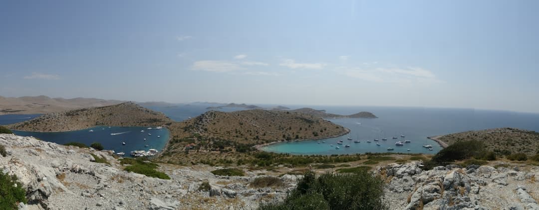
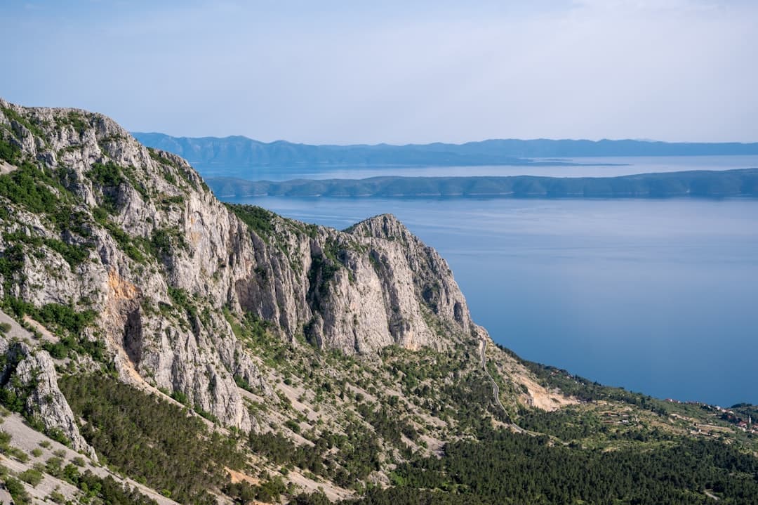
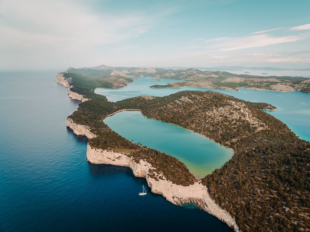
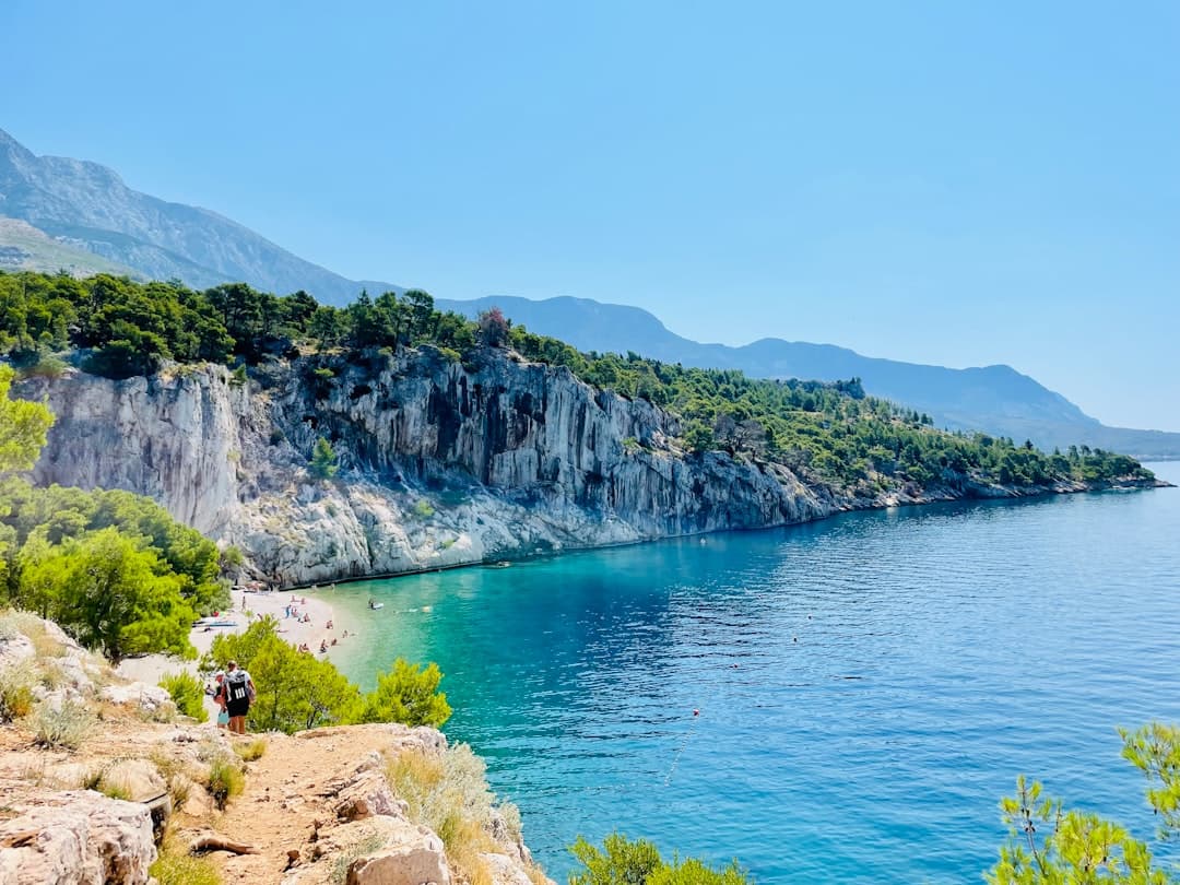
Telašćica is named for and shaped by a single feature: the long, sheltered bay that cuts almost 8 kilometres into the southern flank of Dugi Otok. Inside the bay you will find 25 coves and six small islands, while just over the ridge the western coast falls away in vertical limestone walls known locally as the Stene. That contrast — calm anchorage on one side, open Adriatic drama on the other — is the reason the park exists.

The bay has been called the safest natural harbour in the Adriatic, which is why you will see hundreds of yachts riding at anchor on a summer afternoon. Sailors crossing to or from Kornati treat it as the obvious overnight stop, and several family-run konobas at the head of the bay have built their reputation around feeding the boating crowd. If you arrive on land you will share the place with them, but the park is large enough that the trails and viewpoints stay quiet.

Telašćica's ecological value rests on three things at once: the cliffs and their nesting peregrine and Eleonora's falcons, the saltwater Lake Mir with its underground link to the sea, and the surrounding seabed, which records more than 300 plant and 300 animal species. More than 500 plant species grow on land. The park sits within a wider Natura 2000 protection zone that ties it to Kornati immediately to the south.

Quick Facts

Where it is

Southern tip of Dugi Otok, in the Zadar Archipelago, immediately north of Kornati National Park.

Status

Declared a nature park in 1988; covers 70 km² of land and sea.

Headline numbers

8 km long bay, 25 small coves, 6 islets, 69 km of indented coastline.

Cliffs (Stene)

Up to 161 m above the sea and 90 m below it on the open-Adriatic side.

Entry fee (2026)

€8 per person, €6 per car, free for under-5s; multi-day passes available.

How to get there

Jadrolinija or G&V Line catamaran from Zadar to Sali (around an hour), then 9 km by car, taxi, bike or boat into the park.

A panoramic view across the scattered Kornati and Telašćica archipelago, with bare limestone islets rising from a calm Adriatic.
The Cliffs

The Stene: Croatia's Most Dramatic Coast Edge

The Stene are the headline view. From the Grpašćak fortress lookout the cliffs run south-east in a continuous wall, dropping a full 161 metres to the water and continuing another 90 metres below the surface. The geology is straightforward Karst limestone tilted seaward, but the scale of it is unusual on this coast — most of Croatia's islands shelve gently into the sea rather than ending in a sheer face.

Walk the cliff-top path and you will pass several unfenced viewpoints where the rock simply ends. There is no railing and no warning sign. Stay back from the edge in wind, especially the bura that funnels down from Velebit in autumn and winter, and never try to scramble below the rim — the cliffs are loose at the top and undercut at the base.

The Grpašćak fort itself is a small Austro-Hungarian-era military post that has been converted into a free interpretation centre, included with park entry. A one-hour visit covers the geology, the falcon population and the maritime history of the bay; from the terrace you can spot bottlenose dolphins in the channel between Dugi Otok and the Kornati islands, particularly in early morning and late afternoon.

A sheer limestone cliff face dropping into deep Adriatic water, evoking the 161-metre Stene cliffs on Dugi Otok's open-sea side.
Lake Mir

Lake Mir and the Donkeys

A ten-minute walk from the head of the bay brings you to Jezero Mir — "peace lake" — a 900 by 300 metre saltwater pool sitting just behind the cliffs. The lake is fed through underground channels from the open sea, which keeps it slightly saltier than the Adriatic and a few degrees warmer in summer. The grey silt on the bottom has long been used for therapeutic mud baths, and locals will tell you it is good for joints; the lake is also home to an endemic eel known as the kajman.

Around Mir you will meet the park's most photographed residents: a small herd of free-roaming island donkeys, descendants of the working animals once used to haul olives, salt and stone across Dugi Otok. There are around fourteen of them, they are entirely tame, and they will approach if you have a snack — which you should not give them, since human food is bad for them and the rangers actively discourage feeding.

The 2.2 kilometre loop around Lake Mir is the easiest walk in the park and the one most visitors do. It is mostly flat, marked, and shaded enough to be manageable in summer. A separate 1 kilometre medicinal-plants trail runs from Grpašćak inland to the Gmajno Polje plain, and a 2.5 kilometre route connects Mir Bay to the lake itself.

An aerial view of a sheltered inland saltwater pool ringed by white rock — evoking Lake Mir behind the cliffs of Telašćica.
Getting There

Reaching the Park from Zadar

The classic route is the catamaran from Zadar to Sali, the largest village on Dugi Otok and the gateway to the park. G&V Line and Jadrolinija both operate the route, with crossings of around 60–80 minutes depending on whether the boat stops at intermediate ports. A car ferry on the Zadar–Brbinj line covers a longer route to the northern half of the island and suits anyone bringing a vehicle.

From Sali to the park entrance is about 9 kilometres on a single tarred road. In summer a shuttle bus runs the route on the busiest days, otherwise it is a taxi, a hire car, an e-bike from one of the rental shops in Sali, or a longer 35–40 kilometre cycling loop if you want to ride. Inside the park the road ends at a small car park near Mir Bay; from there everything is on foot.

If you would rather skip the logistics, day-tour boats to Telašćica run from Zadar, Biograd na Moru, Murter, Vodice and Šibenik between roughly May and October, usually combined with a stop at Kornati. The advantage is door-to-door simplicity and a chance to anchor inside the bay for a swim; the disadvantage is that you stay with the boat schedule and rarely have more than two or three hours on shore, which is not enough to walk the cliff path properly.

Looking across a calm Dalmatian bay with boats moored offshore — the kind of sheltered anchorage that makes Telašćica a sailing favourite.
Practical Notes

Planning Your Visit

The park is open year-round but most visitors come between mid-May and mid-October. Buy your ticket at the entrance, on the park website or at the Sali agency — and keep it, because rangers do check at the trailheads. Bring proper shoes (the limestone is sharp underfoot) and at least 1.5 litres of water per person, since there is nowhere to refill once you leave Mir Bay.

Tickets and access

The 2026 entry fee is €8 per adult, €6 per car, with under-5s free. Multi-day passes covering 3 or 7 days work out cheaper if you are staying on Dugi Otok. Tickets can be bought at the park entrance, online in advance through the park website, or at the agency in Sali.

Best season

July and August are hot, dry and busy with sailors; June and September give you warm sea and far fewer people. Spring brings the Mediterranean wildflowers into bloom and is the best time for the medicinal-plants walk. Winter visits are quiet but services are minimal.

Where to eat

The konobas at the head of Telašćica bay open in season and serve grilled fish, octopus salad and the Sali-style fish stew that locals call brujet. In Sali itself, time your visit for the first weekend of August if you can: the Saljske užance festival fills the harbour for three days, with the famously raucous Tovareća mužika donkey-horn band leading the parades.

Safety on the cliffs

The cliff-top viewpoints are unfenced and the limestone is loose at the rim. Stay back from the edge in wind — particularly the bura, which funnels down from Velebit in autumn and winter — and do not let children run unsupervised on the path. The full cliff-top route has uneven footing and is not suitable if you struggle with rough ground or have a fear of heights.

FAQ

Common Questions About Telašćica Nature Park

No — Telašćica is a nature park, a Croatian protected category one step below national park. It was designated in 1988 and is managed by its own authority, separate from neighbouring Kornati National Park. The practical difference is that nature parks allow more traditional human activity (farming, fishing, small-scale tourism) inside their boundaries.

A full day is sensible if you arrive by ferry. That gives you time for the Lake Mir loop, the Grpašćak viewpoint, a swim in either Mir Bay or the lake itself, and a meal at one of the bay konobas. Day-trip boats from the mainland typically give you only two to three hours, which covers the lake walk and not much else.

Yes, and many visitors do. The water is slightly warmer and saltier than the open sea, and the silty bottom is the source of the mud believed to have therapeutic properties. The cleanest entry points are on the southern shore. Avoid swimming directly under the cliffs of the lake's western side, where falling stones are a real if minor risk.

They are free-roaming descendants of working animals, so feral rather than truly wild. The herd of around fourteen lives unfenced inside the park, mostly around Mir Bay. Treat them as you would any large animal: keep your distance, do not feed them, and do not block their path.

Yes — the Telašćica bay is one of the most popular anchorages in the Adriatic and a standard overnight stop on the Kornati circuit. There are mooring buoys in several of the inner coves managed by the park, with a fee paid to the ranger boat that comes around in the evening. Anchoring on your own chain is restricted in some areas to protect the seabed.

The Lake Mir loop and the area around Grpašćak are walkable for most people of reasonable fitness, and you can drive almost to the trailheads. The full cliff-top path is longer and more exposed, with uneven limestone underfoot and unprotected drops, so it is not suitable if you struggle with rough ground or have a fear of heights.

Explore More of Croatia

Discover more stories, hidden gems, and travel inspiration to help you plan your perfect Croatian adventure.